Loučná pod Klinovcem - Loučná pod Klínovcem - Wikipedia
Loučná pod Klinovcem Böhmisch Wiesenthal | |
|---|---|
Shahar | |
 Loučná pod Klinovcemga boradigan yo'l | |
 Gerb | |
 Loučná pod Klinovcem Chexiya Respublikasida joylashgan joy | |
| Koordinatalari: 50 ° 24′46 ″ N. 12 ° 59′23 ″ E / 50.41278 ° N 12.98972 ° EKoordinatalar: 50 ° 24′46 ″ N. 12 ° 59′23 ″ E / 50.41278 ° N 12.98972 ° E | |
| Mamlakat | |
| Mintaqa | Usti nad Labem |
| Tuman | Chomutov |
| Hukumat | |
| • shahar hokimi | Yana Myullerova (Ind. ) |
| Maydon | |
| • Jami | 20,89 km2 (8,07 kv mil) |
| Balandlik | 865 m (2,838 fut) |
| Aholisi (2020-01-01[1]) | |
| • Jami | 121 |
| • zichlik | 5,8 / km2 (15 / sqm mil) |
| Vaqt zonasi | UTC + 1 (CET ) |
| • Yoz (DST ) | UTC + 2 (CEST ) |
| Pochta Indeksi | 431 91 |
| Veb-sayt | www |
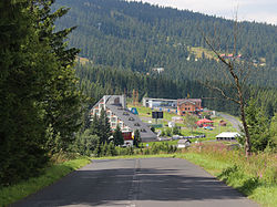
Loučná pod Klinovcem, 1947 yilgacha Cesky Wiesenthal (Nemis: Böhmisch Wiesenthal) shaharchadir Chex Respublikasi. Taxminan 100 kishi istiqomat qiladigan bu shahar Chexiya Respublikasida aholisi kam bo'lgan ikkinchi shahar.
Shahar Germaniya bilan chegarada joylashgan. Bo'lingan shaharning Germaniya qismi deyiladi Oberwiesenthal.
Taniqli odamlar
- Xans Erix Slani (1926–2013), nemis sanoat dizayner
Adabiyotlar
- ^ "Baladiyya aholisi - 2020 yil 1-yanvar". Chexiya statistika boshqarmasi. 2020-04-30.
Tashqi havolalar
| Bu Usti nad Labem viloyati joylashuv haqidagi maqola a naycha. Siz Vikipediyaga yordam berishingiz mumkin uni kengaytirish. |